The Atlas
Maps of the Bible
Ten published maps of the biblical world, drawn from the classic public-domain atlases — George Adam Smith’s Historical Geography of the Holy Land (1915), Bonne’s 1770 engraving of the tribes, and their peers — each attributed and linked to its source, and each opening full-size in a new tab.
The Land of the Book
the stage of most of Scripture — smaller than many counties
Gen 12:5–7 · Deut 34:1–4 · Judg 20:1 — “from Dan even to Beersheba”
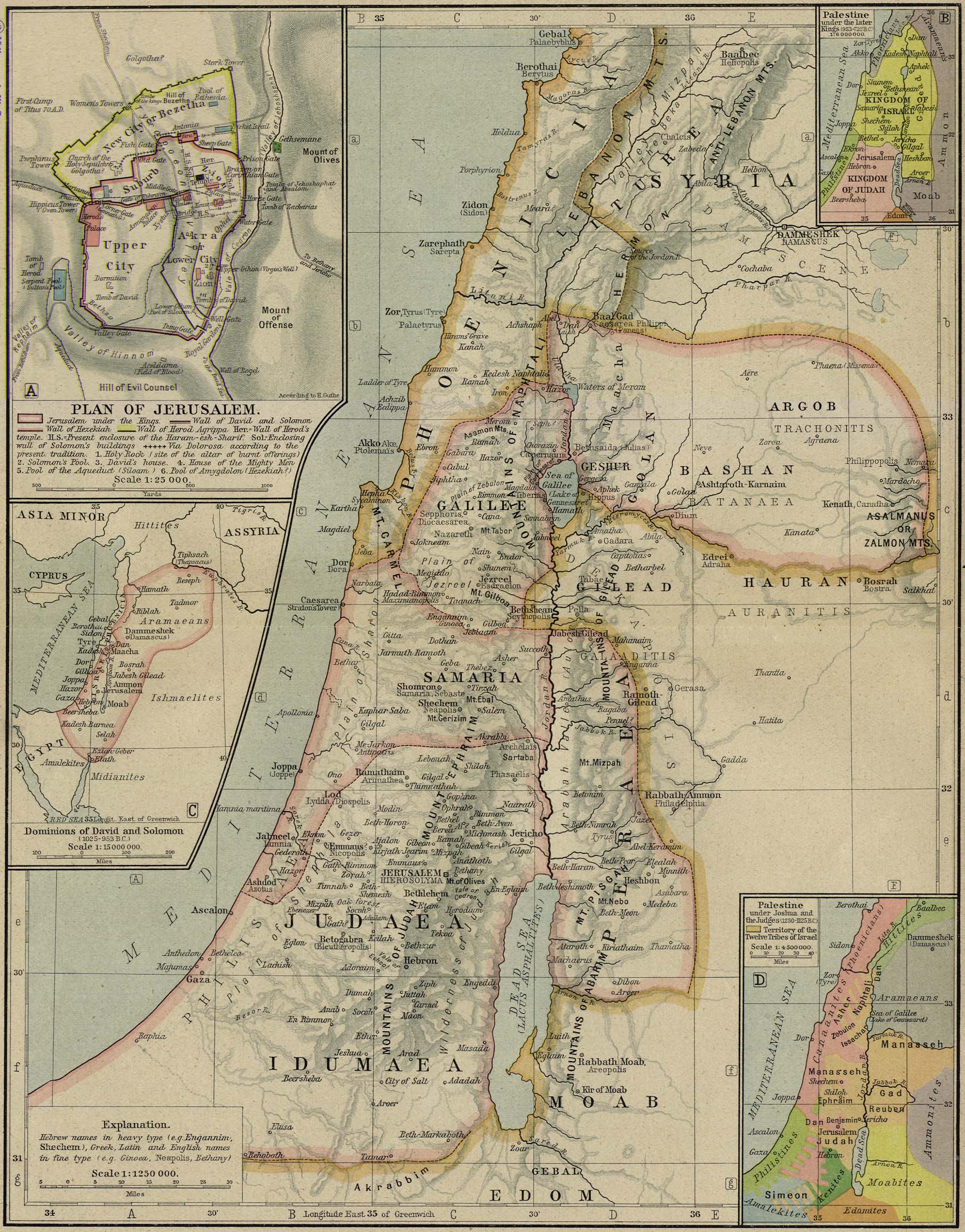
From Dan in the north to Beersheba in the south is about 150 miles; from Joppa on the coast to Jericho in the rift valley, under 50. Almost everything in the historical books happens on this small stage — the coast road and the ridge road, Galilee's lake, the Jordan's deep trench, and Jerusalem on its watershed spine.
The Twelve Tribes
the allotment of the land under Joshua — Bonne's 1770 engraving
Josh 13–21 · Gen 49 · Num 26
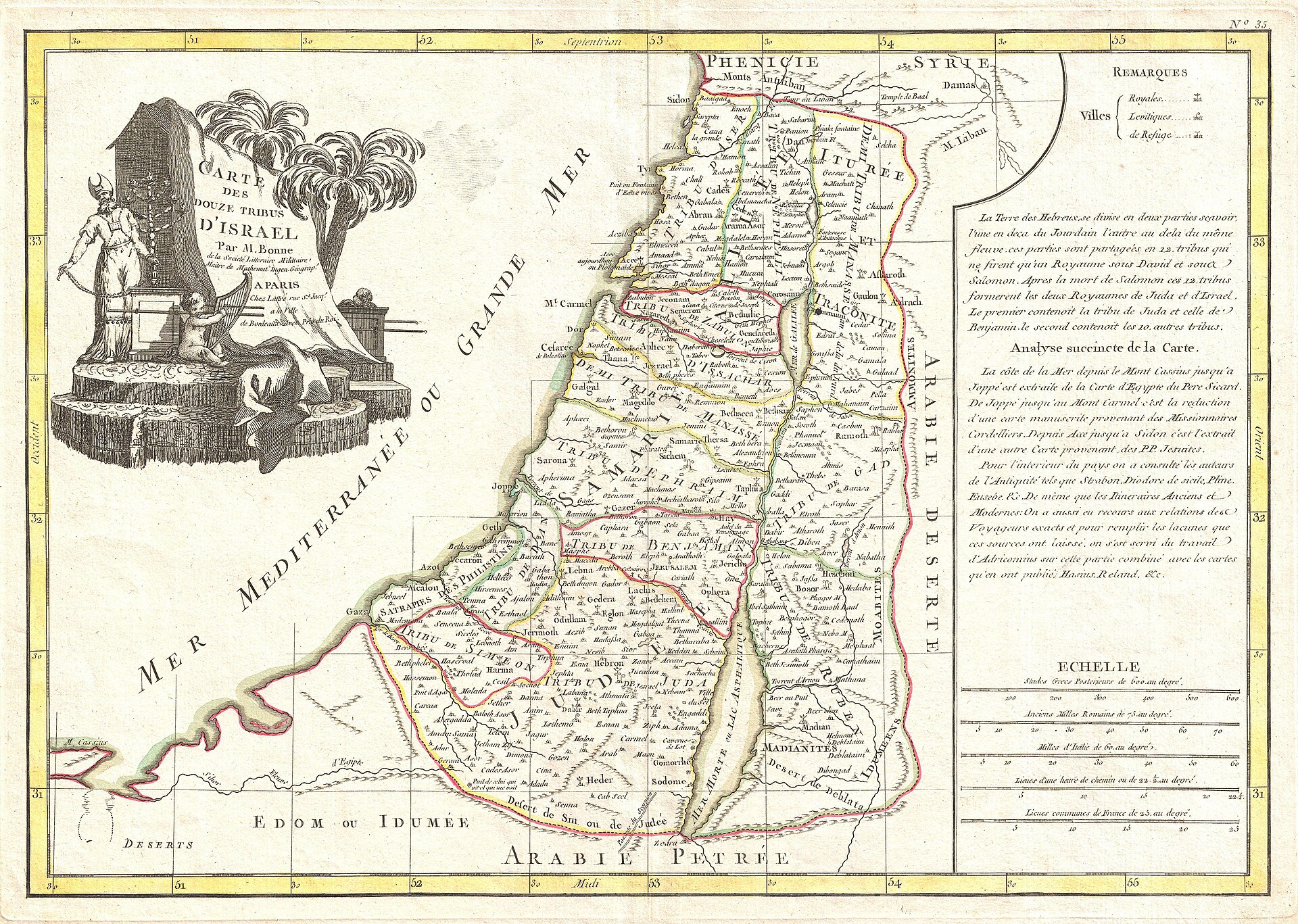
Joseph's portion is doubled through Ephraim and Manasseh, and Levi receives cities, not territory — which is how twelve tribes yield thirteen names and twelve allotments. The borders in Joshua 13–19 are town-lists, not survey lines; every printed tribal map, this 1770 engraving included, is an approximation.
The Exodus Road
Egypt to Canaan through the wilderness — Cram's atlas plate
Exod 12:37 · Exod 19:1–2 · Num 33 (the itinerary) · Deut 1:2
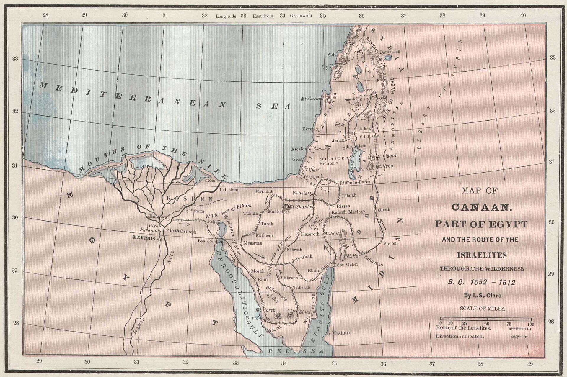
Rameses, the sea, Marah's bitter water, Elim's twelve springs, Rephidim, the mountain — then the long way after Kadesh-barnea: thirty-eight years for an eleven-day journey, ending on Nebo with Moses looking across at what Joshua would enter. Scripture's own itinerary is Numbers 33; the mountain's location is the traditional identification, weighed honestly below.
Where is Mount Sinai? — the contested identificationsExod 3:1; 19:1-2 · Gal 4:25
Scripture locates Sinai “in Arabia” only in Paul’s allegory (Gal 4:25, where “Arabia” in Roman usage included the Sinai peninsula) and never gives coordinates. Three identifications carry the argument. Jebel Musa (south-central Sinai, the route most atlas plates draw) is the traditional site — monastic memory from at least the 4th century (St. Catherine’s), a plain (er-Raha) large enough for an encampment, and a location that fits an itinerary reaching Kadesh-barnea “eleven days’ journey” away (Deut 1:2). Jebel al-Lawz(northwest Saudi Arabia, ancient Midian) is argued from Moses shepherding Jethro’s flocks in Midian when he met the bush (Exod 3:1) and a plainer reading of “Arabia”; its critics answer that Midianite ranges crossed the gulf seasonally, that the proposal’s popular evidences are geological commonplaces, and that it strains the sea-crossing logistics. Northern-route sites (Jebel Sin Bishar and others) fit a shorter itinerary but sit awkwardly with “the way of the wilderness of the Red Sea” (Exod 13:18). No identification is an article of faith; the events, not the summit’s coordinates, carry the covenant.
The Conquest & the Judges
the land as Israel settled it — Smith's 1915 atlas
Josh 3–11 · Josh 21:45 · Judg 1–2
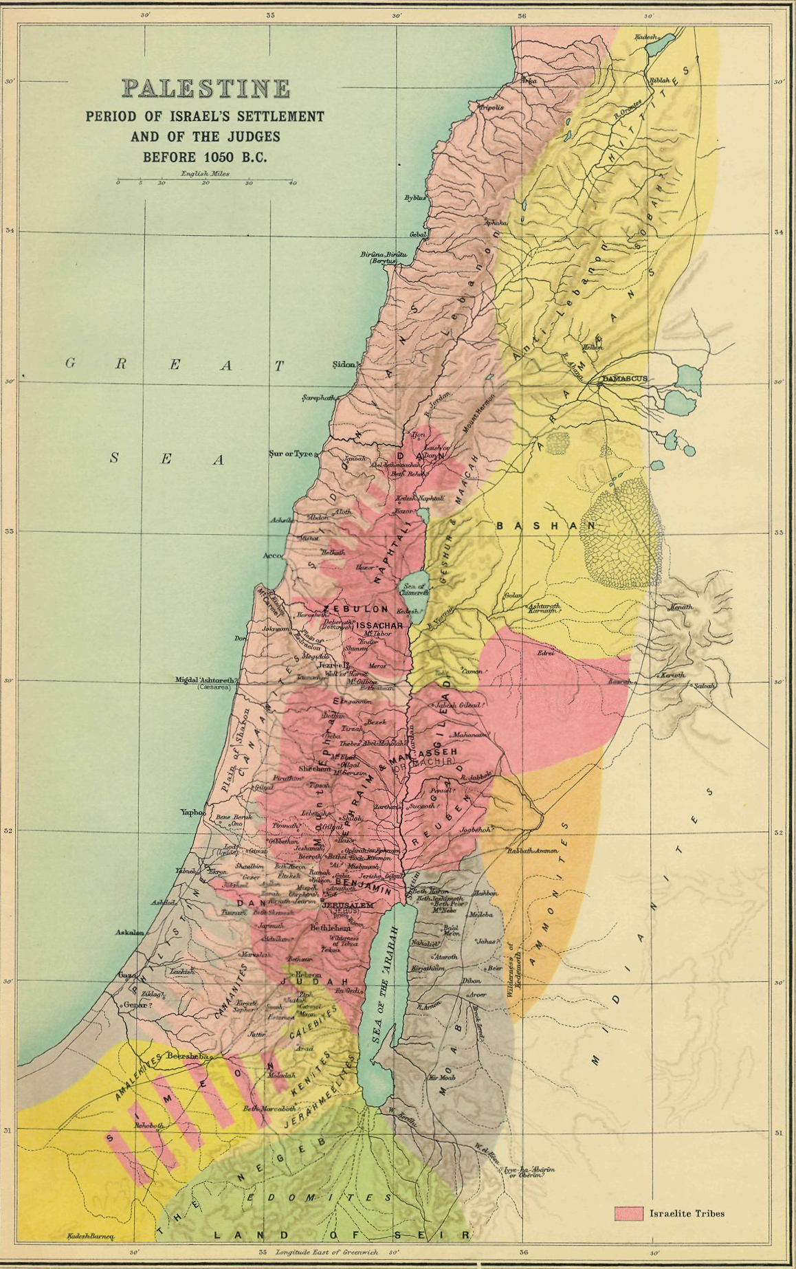
Israel crosses the Jordan and camps at Gilgal — the base every campaign returns to. The center falls first (Jericho, Ai, covenant renewed at Ebal and Gerizim); then the south in one forced march after Gibeon; then the north, where Hazor, “the head of all those kingdoms,” burns. Smith's plate shows the land as the settlement left it — including the plains and valleys the tribes failed to take (Judg 1), where the Judges cycle would turn for three centuries.
The Kingdom of David & Solomon
the united monarchy at its widest reach — Smith's 1915 atlas
2 Sam 8 · 1 Kgs 4:21-25 · 1 Kgs 9:15-19
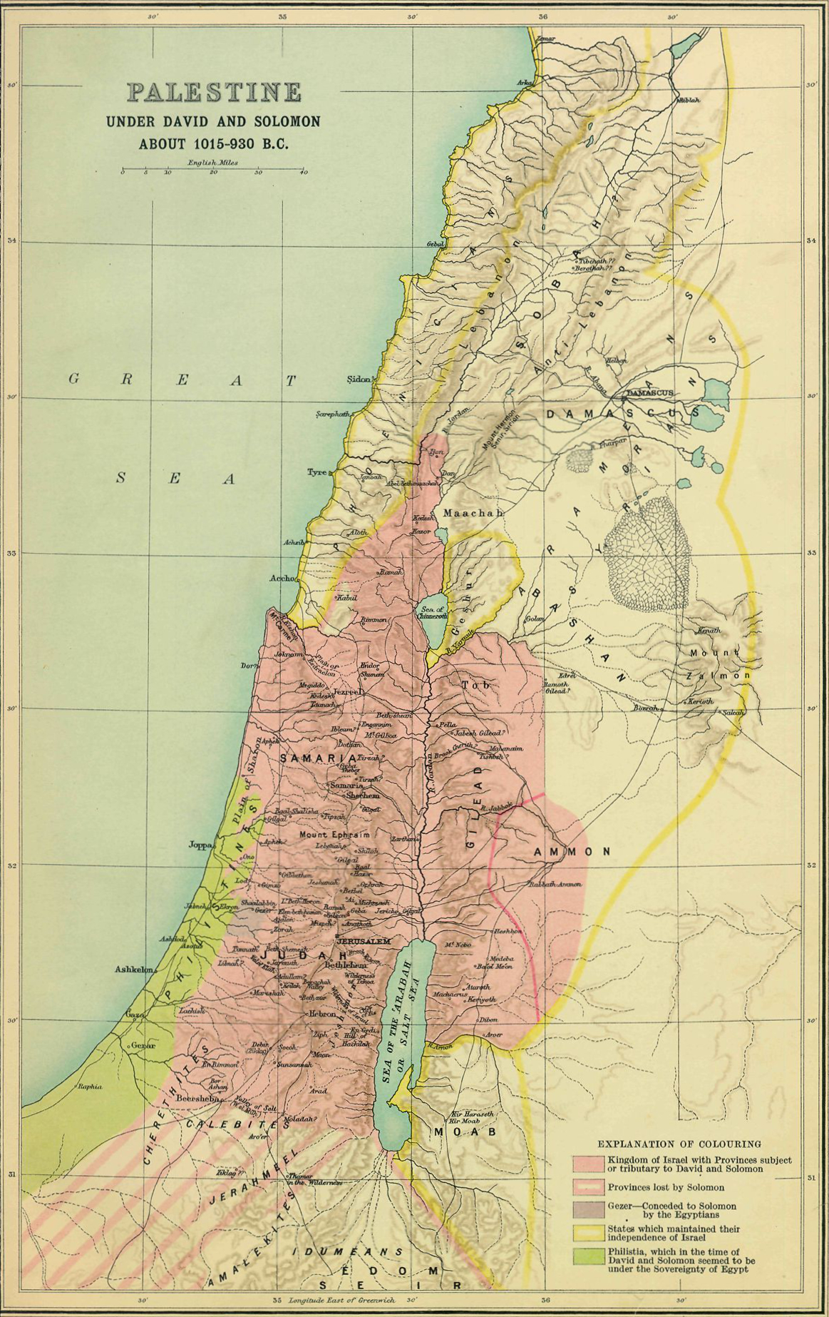
David subdues Philistia, Moab, Ammon, Edom, and Aram (2 Sam 8), and Solomon reigns “over all the kingdoms from the River unto the land of the Philistines” (1 Kgs 4:21). Hazor, Megiddo, and Gezer — named in one breath with Jerusalem's wall in 1 Kings 9:15 — were excavated with strikingly similar six-chamber gates. The refrain of the golden age: “Judah and Israel dwelt safely, every man under his vine and under his fig tree, from Dan even to Beersheba” (1 Kgs 4:25).
The Divided Kingdom & the Exiles
from 720 BC to the exile of Judah — Smith's 1915 atlas
2 Kgs 17:6 · 2 Kgs 24–25 · Dan 1:1 · Ezra 1:1–3 · Jer 29:10
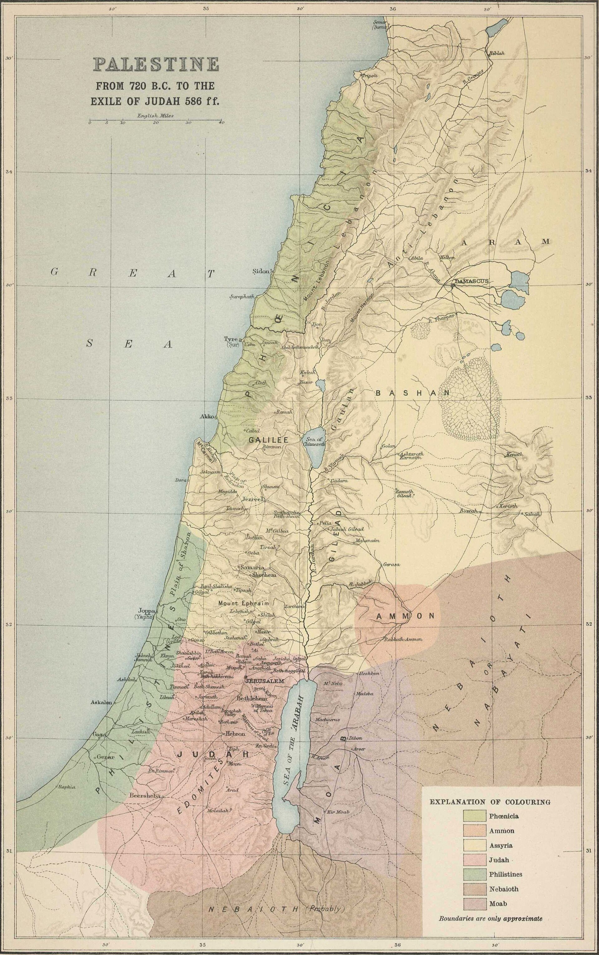
After Solomon the kingdom tears in two: Israel ruled from Samaria, Judah from Jerusalem. Assyria takes the north in 722 BC; Babylon takes the south in three deportations (605, 597, 586). Smith's plate maps the land in exactly this window — the Assyrian provinces standing where Israel had been, Judah alone with its lamp still burning, until Cyrus's decree in 539/538 opens the road home.
The Land in the Time of Christ
Herod's legacy and the regions of the ministry — Smith's 1915 atlas
Matt 4:12–17 · John 4:3–4 · Luke 9:51 · Mark 10:32–34
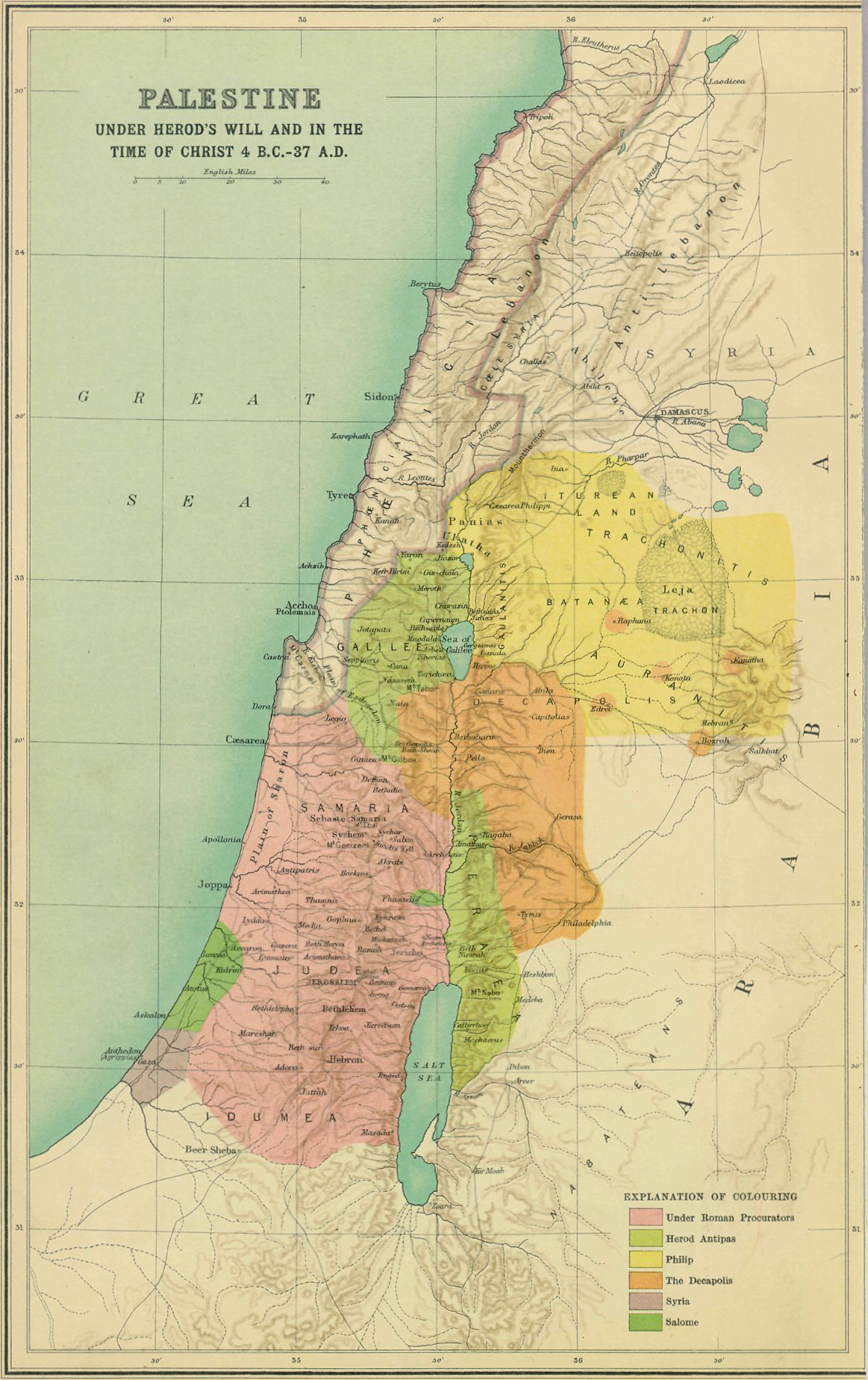
Capernaum, not Nazareth, is the ministry's home base — “his own city” (Matt 9:1) on the lake's north shore. South lies Samaria, which “Jesus must needs go through” in John 4; pilgrims often took the Perean road east of Jordan instead, the route of the final ascent through Jericho. North to Caesarea Philippi for the confession; west to Tyre and Sidon; and everything converging on Jerusalem. Smith's plate shows the tetrarchies as Herod's will carved them — the political map every Gospel scene assumes.
The Word Spreads — Acts 8–12
Judea, Samaria, and the coast under the procurators — Smith's 1915 atlas
Acts 8:1-40 · Acts 9:1-30 · Acts 10 · Acts 11:19-26
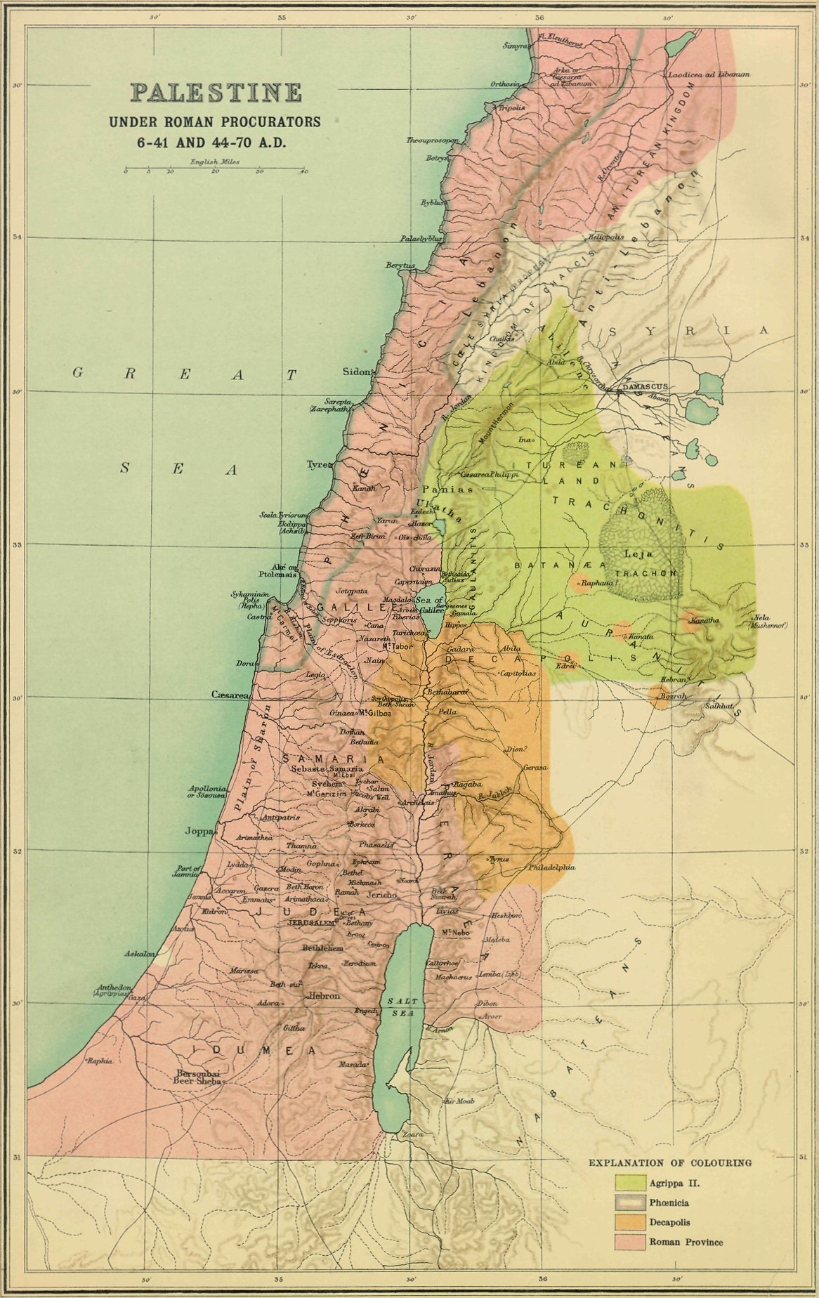
Persecution scatters the church, “and they that were scattered abroad went about preaching the word” (Acts 8:4). Philip goes down to Samaria, then south to the Gaza desert road; Peter works the coastal plain — Lydda, Joppa, and at Caesarea the Spirit falls on a Gentile house; Saul rides for Damascus and meets the risen Lord on the way. The scattered walk the Phoenician coast to Antioch, where the disciples are first called Christians — and from where every journey on the next map departs.
The Journeys of Paul
the missionary journeys — Knecht's classic plate
Acts 13–14 · Acts 15:36–18:22 · Acts 18:23–21:17 · Acts 27–28
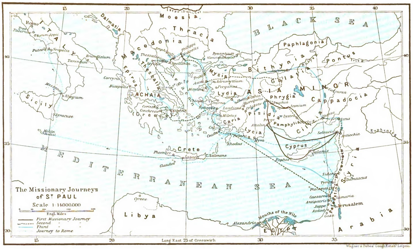
The first journey sails from Antioch through Cyprus into Galatia. The second goes overland through the same churches, then — called through a vision at Troas — crosses into Europe: Philippi, Thessalonica, Berea, Athens, Corinth. The third centers on Ephesus, close on three years. Last comes Acts 27–28: the prisoner's voyage from Caesarea past Crete into the storm, fourteen nights adrift, Malta, and at last Rome.
The Seven Churches of Asia
the postal circuit of Revelation 1–3 — Smith's 1915 atlas
Rev 1:9–11 · Rev 2–3
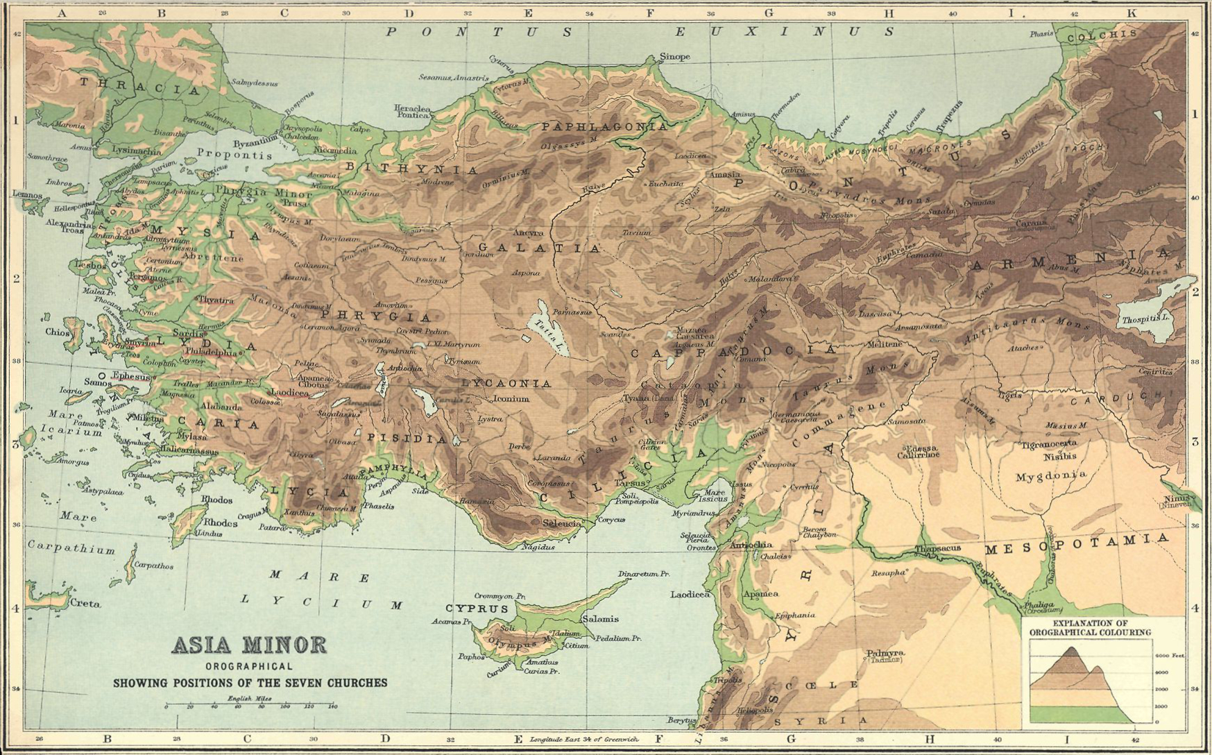
From Patmos, John addresses seven real cities in the order a courier would ride them: up the coast from Ephesus to Smyrna and Pergamum, then inland and south through Thyatira, Sardis, Philadelphia, and Laodicea — a natural circuit on the Roman roads. Seven letters, each opening with a title of Christ and closing with a promise to him that overcometh.
Sources: all plates public domain, license verified per file at Wikimedia Commons (linked under each map) — George Adam Smith, Atlas of the Historical Geography of the Holy Land (1915); Rigobert Bonne (1770); George F. Cram; F. J. Knecht, Practical Commentary on Holy Scripture; Rand McNally (1926). Scripture frames from the passages cited on each exhibit. Every cited work — the sources registry →